Saturday, February 21, 9AM
I don’t envy anyone that has to make a forecast for this event across the area as it has so many moving parts that it will be difficult to pin down snow totals for a specific area. There’s still a full day of model runs before anything begins, but I can’t recall a storm in the past 20 years that was within 24 hours and had this much uncertainty. The difficulty is that there are several pieces of energy that are phasing into a coastal storm and the timing and location of that phase will ultimately determine the outcome for central MD. If you want to be assured of a snowstorm, the best local’ish place to be is probably Delaware as they are further east and north enough to catch the full brunt of all the model’s placement of the developing coastal storm. Most areas on the eastern shore will start as rain on Sunday, but by Sunday evening, the rain changes to heavy snow with extremely high winds. Blizzard Warnings are up for the coastal areas of Delaware, extending north to New York, and will likely be expanded into New England later today. If you’re on the coast, Sunday night is going to be the real deal for a winter storm. Heavy snow, high winds, and huge drifts.
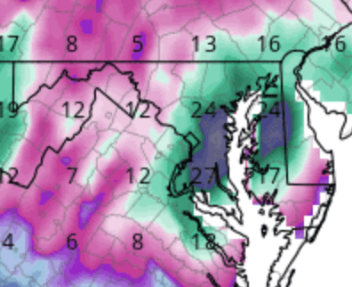
For central Maryland, we have several issues to overcome to get accumulating snow. Marginal temperatures through the day on Sunday are likely a problem. I am confident that it’s going to snow tomorrow, but with temperatures in the mid 30’s and a late winter sun angle, it’s going to be difficult to get accumulations on anything other than grassy surfaces. The only thing that could make tomorrow impactful is heavy snow rates, and for that to happen, we need the phase to happen early and the low to form and hover close to the coast. The gfs has that, but the euro does not. My initial guess, which could be really wrong, is that tomorrow will be a pretty day of falling snow but with minimal impact. By tomorrow evening, the coastal storm really starts cranking and it will pull cold air down so that temperatures around sunset will fall below freezing. That’s when things could get interesting but again will be determined by the placement of the coastal storm. Too far east and it’s just light snow, but if it’s closer to the coast, we could have several hours of moderate snow that would accumulate quickly. I do think tomorrow night has the potential to be impactful for the area. The NWS has issued, and recently expanded, Winter Storm Watches for at least 5″ of snow for the entire area. This is only a watch and it means the potential is there, but it is not a forecast. Just my thoughts, but the areas most likely to exceed the warning criteria from the coastal storm are along the fall line just west of I-95 and then points east. I think these areas could end in the 4 – 6″ range with more possible close to the Bay, especially to the north. Later today the watches will either be upgraded to a warning or just an advisory, so keep an eye on the NWS site to get an idea of what they expect. If your county goes pink, they think you’re going to see 5″ or more of snow. If it goes purplish, that’s an advisory for less than that.
The final complicating piece to all of this is a trailing upper lever low that will cross the area Sunday night. Models have been pointing to a relatively narrow band of nearly stationary heavy snow developing somewhere west of I-95 that could dump a lot of snow in a very short time. That location is very difficult for anyone to pin down and will probably be a nowcasting situation. So, to reiterate the difficulty in making a forecast, it’s entirely possible that areas near the Bay end up with 8″ of snow from the coastal storm, and somewhere west of 95 ends up with 8″ of snow from the upper level low, and some areas in-between end up screaming at the sky. I’m going wait to see what the midday model runs say and then update.