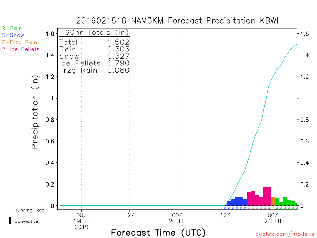
Most of the evening guidance is in and though there are still a lot of unknowns, we can start checking off boxes from most confident to least confident.
Timing may still change slightly, but right now all models say that snow will develop from southwest to northeast across the area on Wednesday morning from about 6AM to 8AM. The snow is expected to intensify quickly causing temperatures to drop several degrees below freezing, and as a result, snow will have no trouble accumulating. There is an abundance of moisture with this system as its source is the Gulf and will bring 1 to 2″ of liquid equivalent across the area. Of that, at least half will be frozen (some combination of snow, sleet, freezing rain). The NWS’s Winter Storm Watches remain in effect and I expect that advisories and warnings will be issued with the Tuesday morning package or by noon tomorrow at the latest. I think all counties along and west of I 95 will go to warnings, with any advisories limited to Calvert and St. Mary’s counties in southern MD. Regardless of a warning or advisory, Wednesday is going to be a difficult travel day.
Of lesser confidence is how long we stay snow on Wednesday. I think the snow will come in quickly and heavy enough to give most of us at least 3″ by noon on Wednesday, and even more in the area where the highest rates set up. Models are suggesting the possibility of localized 2 or more inches per hour but where that happens is unknown right now. Another unknown is that although we have a well-positioned high pressure to the northeast that will be forcing cold air down the coast, the storm is off to our west and will bring warm southerly air aloft over the cold air. As a result, we will change from snow to sleet at some point during the day Wednesday. Obviously, the areas that transition the slowest will end up with the most snow, and quite possibly, a lot of it. In the areas that transition to sleet, it is now looking like they will stay sleet for an extended period, and it’s quite possible that sleet ends up being the predominant precipitation type across the 95 corridor. Below is the current 3KNAM output for BWI on Wednesday. I’m not saying it’s right, but it shows 3″ of snow followed by a ton of sleet. The good news is that it has very little freezing rain. Sleet is terrible for travel, but at least it wouldn’t bring down trees like last week’s storm.

Hopefully, the models start coming to a consensus on the unknowns overnight, but either way, I’ll update first thing tomorrow (Tuesday) morning.