This is where we are right now. Snow still arrives tomorrow morning and probably earlier than the noon I initially thought. Most models bring accumulating snow in from southwest to northeast from about sunrise to 10AM. Snow will continue through the afternoon in varying intensities from light to moderate with accumulations from 3 – 6″. The areas with the best chance of seeing periods of heavier snow will probably be south of I-70 because the warm air aloft will slowly run out of steam as it continues pushing in from the southwest. Regardless, I think the NWS will issue Winter Storm Warnings for most areas along the 95 corridor for tomorrow’s snow. The snow will lighten, and change to freezing drizzle from south to north between 6 and 10PM tomorrow evening. That happens because without steady precipitation mixing and cooling the column above, the warm air noses in and creates a layer of air slightly above freezing. Think of it as the icing layer between to cakes. It’s cold enough above for snow, and cold enough below, but the falling rate of precipitation isn’t strong enough to mix and overcome the icing layer (see what I did there?). Snow falls from above, hits the warm air and melts, and then falls into the bottom cold layer and freezes. Anyway, to be clear, the current Winter Storm Watches only covers the period from 6AM Sunday to 6AM Monday. That’s important because it does not take into account what may fall on Monday. And that’s still the tricky part.
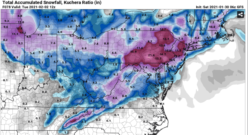
So why is that part of the system so complicated and difficult to pin down? The obvious and easy reason is that it’s difficult to know where the new storm forms. But it’s even more complicated than that. The new, developing storm is going to be very dynamic and there will be huge disparities in snowfall over short distances. These types of redeveloping systems are usually too far north for our area, and are more common from the Philly area and northeast from there. However, in this situation, the models have been showing a strong block to the northeast so that in this case there’s the chance the storm forms at a low enough latitude that we get some snow on the “backside” of the system. However, recent model trends have not been good for getting the best of Monday’s snow. I still think that we see more snow developing Monday morning around sunrise, but I don’t feel good about it being heavy, especially in the areas south of I 70 and west of about 97. The areas that have the best chance of seeing the heavier band (called the CCB – cold conveyor belt) is to the northeast of Baltimore along 95 to Philadelphia. But it’s still not a done deal. As I’ve said in past posts, snowfall maps should not be used to forecast snow amounts, but they are an easy way to see what models “think” will happen. I think these maps show how difficult this system will be to predict until early Monday. All of these maps (from www.pivotalweather.com) include the snow tomorrow, and then the possible snow on Monday. All of these maps, and many, many more, are free and I highly recommend anyone with an interest in weather bookmarking the site above.
First, the GFS snow map from 6z this mornin. It suggests 2 – 4″ tomorrow and the rest from Monday. Notice the higher amounts in northern MD and southern PA where most is from Monday.
Here’s the Euro from 0z this morning. It suggests 2 – 4″ tomorrow and the rest on Monday. By the way, there is an off hour run at 6z that is only available on pay sites so I can’t post it here, but it’s a little better than this.

Then we have the short-range models. First the NAM. It shows a solid thump tomorrow of 4 – 6″ tomorrow and the “rest” on Monday.
And the crazy RGEM. Shows about 3 – 5″ tomorrow and then piles on Monday. Seriously, this is not correct, but damn, it’s fun to look at, and it also illustrates the potential with a developing coastal. We get crushed on Monday, Monday night, Tuesday…

So, which one is correct? I can just about guarantee that none of them are exactly right, but I think the short range models like the NAM have the best handle on tomorrow. Beyond that, there’s too much uncertainty, but I like my guess of 2 – 4″ more for Monday with a storm total of 6 – 10″ across central MD.
I’ll keep updating.
