I said I’d update but there are no changes worth mentioning. But do a snow dance for Friday, though I think it’s hopeless.
Category: Uncategorized
Tomorrow’s Showing Some Life
The mid-day model runs are suggesting that tomorrow could be a little more wintry than thought. It still isn’t expected to be a big event, but with rain changing to snow and falling temperatures during the day, things could be pretty slick quickly in the morning. The National Weather Service has not issued any advisories yet, but I expect that to change this afternoon.
In a little more detail, enjoy this afternoon’s mild temperatures because this may be the warmest day for awhile. A cold front will cross the area overnight and a wave of low pressure will ride along the front bringing rain that starts around midnight. Once the front crosses the area, temperatures will fall and eventually change the rain to snow. I am expecting that sometime around sunrise. Temperatures will continuing falling through the morning, and since roads will likely not be pre-treated, quickly deteriorating conditions are possible during the morning commute. Overall, I think most of us will see a general 1 – 3″ accumulation, depending on how soon we change to snow, and then it’s going to be darn cold around here at least through the weekend.
As of now, the Friday night system is well south and not expected to result in anything more than partly cloudy. I’ll update again tonight around 10PM with any changes for tomorrow.
This Week
The overnight Wednesday into Thursday event is looking more likely today, and though it doesn’t look like more than a nuisance event for most areas, the timing is during the morning rush hour on Thursday. Still a little early for details, but after seeing the midday model runs, right now it looks like rain beginning after midnight tomorrow night, then mixing with and changing to snow well before sunrise. Accumulations look to be at most an inch or two, and road conditions will be determined by whether or not the temperature can fall below freezing Thursday morning. There’s a lot of residual salt on the roads now, but any rain would wash it off, and worse, prevent pre-treatment. The timing could be crummy for school officials, and if temperatures dip to below freezing, roads could quickly become slick. We can wait for the mesoscale short-term models to get into range before making any serious calls, which will be tomorrow afternoon.
The Friday night and Saturday system is one that has a lot of potential and one that I thought we actually had a chance to reel in, but today’s runs do not look nearly as promising as they had last night. Unfortunately, I think Thursday’s system could ultimately mess up our chances for a real snowstorm this weekend. Hopefully that changes, but I’m not as confident as I was yesterday. I’ll periodically update on both possible events as the models converge.
Looking beyond this week, the cold pattern and fast flow of disturbances looks to continue, so more chances next week.
A Couple of Possibilities to Watch
The models don’t agree on how the week plays out but more snow is possible this week. The first opportunity would be a relatively light event early Thursday, and the other is a more significant possibility Friday evening and Saturday. Neither of the two has model consensus with the gfs bullish for the Thursday deal, and the Euro showing consistency for the weekend. No point in parsing details until their is some model agreement, so I’ll update tomorrow afternoon.
Personally, I’m really rooting for the weekend deal. It looks like it could be a cold storm and then cold air in its wake the following week. There’s not much better in winter than a powder bomb that hangs around for a week.
No Changes Yet
No reason to update things as the forecast hasn’t really changed. I keep expecting the models to throw us a curveball but they’ve been remarkably consistent since Wednesday. That’s pretty unusual for a complicated system such as this one, but if they hold the course, then snow should develop from south to north tomorrow afternoon between 2 and 3 PM. The snow may be heavy at times in some areas, and may accumulate 1 to 2 inches, but that will depend on how long precipitation takes to change to sleet and then eventually rain. Gusty winds tomorrow night and Monday with the possibility of snow showers Monday morning.
Regardless of how tomorrow pans out, winter looks to hang around for the second half of January.
Sunday Storm Update
The models refuse to budge on the idea of a sloppy storm across the metro area. They continue to show a quick moderate to heavy snow moving in during the early to mid-afternoon hours on Sunday, then transitioning to sleet by evening, and eventually all rain Sunday night. Presently, rain should end before sunrise Monday, but as the storm pulls away to the northeast, there is a chance of some snow showers redeveloping Monday morning. Strong winds Sunday night and Monday are also possible, so hopefully no areas get much in the way of freezing rain. We are still 48 hours out from any precipitation, so no point in going in to too many details. I’ll update periodically over the weekend, especially if there are any changes.
Sunday Potential (Again)
I had written an update this morning, but it’s floating somewhere in space, so I’ll quickly recap. A storm will develop south of the area and likely impact the region Sunday and Sunday night. This is the type of system that could bring snow, sleet, rain, or a mix depending on the exact track of the low pressure center. Too far to the west and the counterclockwise circulation brings in warm air, so we want a track where the storm stays to our south and east.
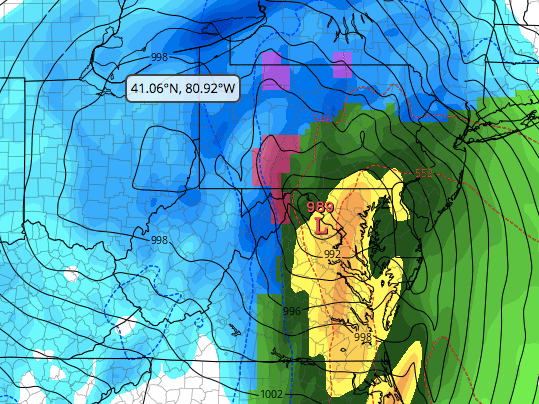
Right now, both operational models of the GFS and Euro show the storm coming too far west, and as a result, central MD starts with a period of moderate to heavy snow, then changes over to rain. However, both ensembles of the GFS and Euro show the low may still take a favorable track for snow (think of the ensembles as mean or average of many model runs where there are very minor changes to input). To illustrate my point, here is a graphic of this morning’s operational GFS run (graphics courtesy of Tropical Tidbits). Notice the position of the low center in the operational run. It’s much too far west for our liking resulting in warm air pulled in over central MD causing rain. The panels before this showed several hours of snow, but the predominant precipitation type is rain.
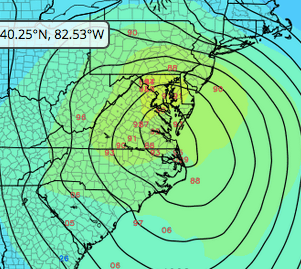
On the other hand, the ensembles, shown below, illustrate the uncertainty with this system. Notice the red numbers that show the position of the low center from all the output runs of the ensembles. If you took the average of all of those placements, it would be a point south and east of the operational shown above.
We are still five days out, so there will certainly be changes before Sunday. Hopefully for the good, but right now I think we might get slop. I’ll update periodically as things change.
Some Icy Conditions Possible Monday
Be careful on your commute in the morning as roads and sidewalks may be icy. Daytime temperatures will be slow to rise so conditions may be slow to improve.
Nothing else on the immediate horizon, but the pattern looks to be ripe with potential as soon as this weekend.
Possible Icy Sunday Morning
For anyone heading out tomorrow morning for Sunday services and / or to the bar to get a good seat for the Raven’s game, be prepared for the possibility of icy roads and sidewalks. Although temperatures should warm above freezing tomorrow, this cold air mass will be tough to dislodge from the surface so watch out for freezing rain.
Temperatures drop back below freezing tomorrow night, and after a day of rain washing the salt off the roads, there is a chance of refreezing for Monday morning’s commute. The rest of the work week looks dry and seasonable, but we should keep an eye on next weekend and beyond as the second half of the month still looks active.
It’s Been a Long Time
I was sitting by the window this morning going through yesterday’s model runs trying to determine what each forecasted well or not so well, and there was a sudden gust of wind that created a backyard mini-blizzard. Swirling snow off the roof and trees, and it was an instant snow globe. In that moment, it occurred to me that this is the first time in several years that it legitimately feels like winter. Not to get sappy, but at a time when days like today, where snow is on the ground and temperatures struggle to reach freezing, are increasingly rare, I find it settling when they happen. There’s a sense of order and stability for me when the seasons act like they are supposed to, or at least how I’ve defined how they are supposed to. Winter in our area can be gray, dull, and seemingly endless, but my memories and snapshots of sledding on the elementary school hill during a snow storm, or a stretch of deep cold that transformed the local pond and creek into the neighborhood playground, are among my favorites. Real winter around these parts is elusive, so I say bring on more. And so much for not getting sappy. Sheesh.
Back to weather and looking ahead, after a couple of cold days today and tomorrow, temperatures should moderate ahead of our next system on Sunday. There may be enough cold air lingering that precipitation may start as a mix of slop, but right now rain looks to be the predominant precipitation type Sunday afternoon and early evening. We may have to keep an eye on Monday morning for refreezing as cold air returns behind the system, but we can worry about that later in the weekend.
Next work-week looks dry and seasonable, but there are signals on both the GFS and Euro that a storm out of the Gulf could be a player next weekend. That would be unusual for a Nina winter but not unprecedented, so we will keep an eye on that too. And looking way out past next weekend, we could be going into a deep freeze. The GFS shows some days struggling out of the teens and lows in the single digits. Frankly, and completely dreaming, but if we got a major snowstorm next weekend followed by a week or two of deep cold, you wouldn’t hear a complaint from me the rest of the winter.
Next update on Sunday evening unless something unexpected pops up.
