Friday Morning

Most models agree that snow develops overnight in central MD, possibly beginning as sleet in some areas, and continuing until about 7AM.  I think the heaviest snow will fall between 2 and 6AM and accumulate from 1 to 4″ from the DC beltway to the PA line respectively.  For most of us, I think a general 2 – 3″ should be expected.  If right, then there will probably be delays in the morning.  Conditions should improve by 9AM due to marginal temperatures and a stronger spring sun so we should all do our homework.

Looking ahead, the models develop and enhance a second wave Friday night which will probably not have immediate impacts for us on Saturday, but may set the stage for a more significant event Sunday night into Monday.  More on that over the weekend.


Still an Evolving System for Tomorrow

There are still some question marks as to how the system tonight will ultimately unfold and the impacts for the rest of the weekend.  Some of the models are now showing a second wave crossing through the region overnight Friday into Saturday with some coastal development that may have impacts for the northern areas.

For now, and just a tentative guess that I’ll refine later, but sleet and snow should develop after midnight and continue into the morning commute on Friday, ending by mid-morning.  Accumulations of 1 – 3″ from the ICC north.  Less frozen precip is expected to the south that would cut down totals around the DC area.

If there is another wave that develops, that would bring precip back into the area overnight Friday and Saturday, but that is low confidence right now.  I’ll update later this afternoon after the midday model runs.

An Upcoming Active Pattern

The next week or so is going to bring a fairly active weather pattern to the mid-Atlantic with several opportunities for some snow across the region.   The models are understandably having a difficult time keying on which waves in the atmosphere that may gel into a storm, so it’s impossible to say with any certainty of what to expect beyond a few days.  However, in spite of my skepticism, this afternoon’s model runs have pretty much come to an agreement that our first opportunity for snow will be late Thursday night and early Friday morning.  Right now, models suggest the possibility of an inch or two of accumulation across central MD by 7AM Friday morning which may cause some problems for the AM commute.  I’ll update periodically over the next couple of days as the forecasts become more accurate.

After Friday, there looks to be several other chances for snow, and I think Sunday night into Monday will be the next window of opportunity.  Regardless of whether that system brings rain or snow, behind it will bring some fairly cold air for March early next week.

There Still May be Some Winter Left

By the time March rolls around I’m pretty much ready for spring, but just like the last several years, winter may still have some punch left.  The first chance of any winter weather is predawn on Friday with the Euro showing a minor 1-3″ event, but the GFS has rain so it’s only a low confidence possibility right now.

Beyond Friday, an arctic front passes late Saturday and we go much below normal in temperatures which may set the stage for a significant event next week.  I’ll update this week as needed.

Wednesday Update (5AM Tuesday)

As expected, the NWS has issued Winter Storm Warnings for all counties in central and northern MD for heavy snow, sleet, and freezing rain beginning early Wednesday.  Expect snow to begin across the metro areas between 6 and 8 AM Wednesday and quickly become moderate to heavy across the region.  The models still show that there will likely be some localized areas that see very heavy snow but that area depends on what model you like.  In any case, all areas will probably see at least moderate snow.  In the early afternoon, the snow will begin to transition to sleet and freezing rain from southeast to northwest, but temperatures will likely be at or below freezing through Wednesday evening.  Temperatures should climb to above freezing by Thursday morning which will improve conditions dramatically by midday Thursday.

Accumulation forecasts are difficult because of the transition. I think 3″ or more of snow across the area by 11 AM is a reasonable call, but many areas will see considerably more on top of that. In then end, I think a general 3-6″ is likely, with the possibility of some localized areas getting a little more.  But regardless of what type of frozen precip is falling, tomorrow will not be a good day to be on the roads. The good news is that with a Winter Storm Warning in place, schools will have an easy call and may even start making announcements for closings tonight.

Wednesday Update (6PM Monday)

Most of the evening guidance is in and though there are still a lot of unknowns, we can start checking off boxes from most confident to least confident.

Timing may still change slightly, but right now all models say that snow will develop from southwest to northeast across the area on Wednesday morning from about 6AM to 8AM.  The snow is expected to intensify quickly causing temperatures to drop several degrees below freezing, and as a result, snow will have no trouble accumulating.  There is an abundance of moisture with this system as its source is the Gulf and will bring 1 to 2″ of liquid equivalent across the area.  Of that, at least half will be frozen (some combination of snow, sleet, freezing rain).  The NWS’s Winter Storm Watches remain in effect and I expect that advisories and warnings will be issued with the Tuesday morning package or by noon tomorrow at the latest.  I think all counties along and west of I 95 will go to warnings, with any advisories limited to Calvert and St. Mary’s counties in southern MD.  Regardless of a warning or advisory, Wednesday is going to be a difficult travel day.

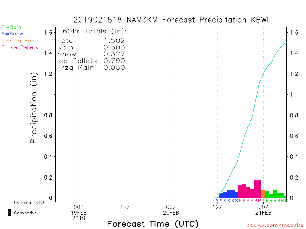
Of lesser confidence is how long we stay snow on Wednesday. I think the snow will come in quickly and heavy enough to give most of us at least 3″ by noon on Wednesday, and even more in the area where the highest rates set up.  Models are suggesting the possibility of localized 2 or more inches per hour but where that happens is unknown right now.  Another unknown is that although we have a well-positioned high pressure to the northeast that will be forcing cold air down the coast, the storm is off to our west and will bring warm southerly air aloft over the cold air.  As a result, we will change from snow to sleet at some point during the day Wednesday.  Obviously, the areas that transition the slowest will end up with the most snow, and quite possibly, a lot of it.  In the areas that transition to sleet, it is now looking like they will stay sleet for an extended period, and it’s quite possible that sleet ends up being the predominant precipitation type across the 95 corridor.  Below is the current 3KNAM output for BWI on Wednesday.  I’m not saying it’s right, but it shows 3″ of snow followed by a ton of sleet.  The good news is that it has very little freezing rain.  Sleet is terrible for travel, but at least it wouldn’t bring down trees like last week’s storm.

NAM3KPRECIPPOTENTIAL18Z

Hopefully, the models start coming to a consensus on the unknowns overnight, but either way, I’ll update first thing tomorrow (Tuesday) morning.

Wednesday

I’ve deliberately not written anything regarding Wednesday’s potential storm for fear of jinxing it, but with confidence growing and Winter Storm Watches issued across all of central and western MD, it’s time to take this event seriously.

Unfortunately, as was the case with last week’s system, we will be on the wrong side of storm so it will not be an all snow event, but with a well-placed high pressure center to our north east, dense, cold air will be funneled down the eastern seaboard at the lower levels and forced to dam up against the mountains to the west.  This is going to be one of our classic cold air damming (CAD) events with heavy snow transitioning to sleet, freezing rain, and eventually rain.  Once the heavier cold air gets established at the surface, it takes a long time to get scoured out, so we are once again looking at a prolonged icing event for the normally favored areas to the west and north of I 95 with some areas staying below freezing for most of the event.

One big difference with this system compared to last week is that there is likely going to be a period of heavy snowfall Wednesday morning into the early afternoon before enough warm air infiltrates the upper levels to begin the transition to sleet.  As a result, snow accumulations of greater than 3″ of snow are likely across the entire area, with many areas receiving upwards of 6″ or more.  Determining the details of who gets how much and the timing on the transitions from snow to sleet to the dreaded freezing rain are yet to be determined, but suffice it to say that travel on Wednesday and Wednesday night will likely be discouraged across all of central MD.

I’ll begin regular updates on this storm with the next coming this evening.

Saturday

Anytime this winter that I’ve mentioned a good pattern showing up in the medium range, it’s fizzled to nothing, so it’s pretty exciting to see this afternoon’s Euro model run hold the course for the possibility of snow for Saturday.  The GFS is still weak sauce to the south, and the NAM doesn’t even know there’s a storm brewing, but having the Euro on our side within 3 days is the hand that I think we want to be holding at this point.  Obviously, there are still an endless number of ways we can get shafted, but right now I like our chances at a 2 – 4″ snowfall in central MD.

Verbatim, the Euro has the most snow just to our southwest, but there are going to be changes before the weekend, so no point in getting caught up in specifics.  The biggest worry is that the coverage area of snow is pretty narrow, so if the snow materializes, not all of us would be getting in the jackpot.  Here’s a visual of the current Euro snow map to see what I’m talking about, but use it with caution.  Snow maps are pretty, but rarely accurate from this range.

Eurosnowsaturday

Between now and Saturday, there is going to be some pretty nice weather, so enjoy it while you can.  Beyond Saturday, the pattern looks slightly colder than normal and very active.