Saturday, January 4, 9:30AM
The National Weather Service has issued Winter Storm Watches across all of MD for the expected snowfall late Sunday night and Monday. The exact track has yet to be determined, but the major models suggest at least 4″ of snow for the entire area beginning around 1AM Monday morning. With temperatures expected to be below freezing across central MD for the duration of the storm (and probably for the entire workweek after), travel and schedules will likely be impacted. For the weather nerds (that is a term of endearment), more details follow.
A couple of days ago, I was concerned about a north trend in both the GFS and the Euro. Long- time followers of The Weather Mill know of this specter and how it can bring simultaneous tears of joy or heartache depending on the circumstances. January 30, 2010, is an example. That was the winter of the three blizzards; one, the week before Christmas, 2009, and the two that were days apart in February 2010. After the blizzard in December, we settled into a non-snow pattern through late January. Then, a storm that was expected to bring snow to the Carolinas, was suddenly nudged by the north trend specter and gave us a decent snowstorm bringing tears of joy to Mid-Atlantic snow-weenies, while Carolinians wept. You won’t find the term “north trend specter” in any meteorological textbook, but I assure you, it exists.
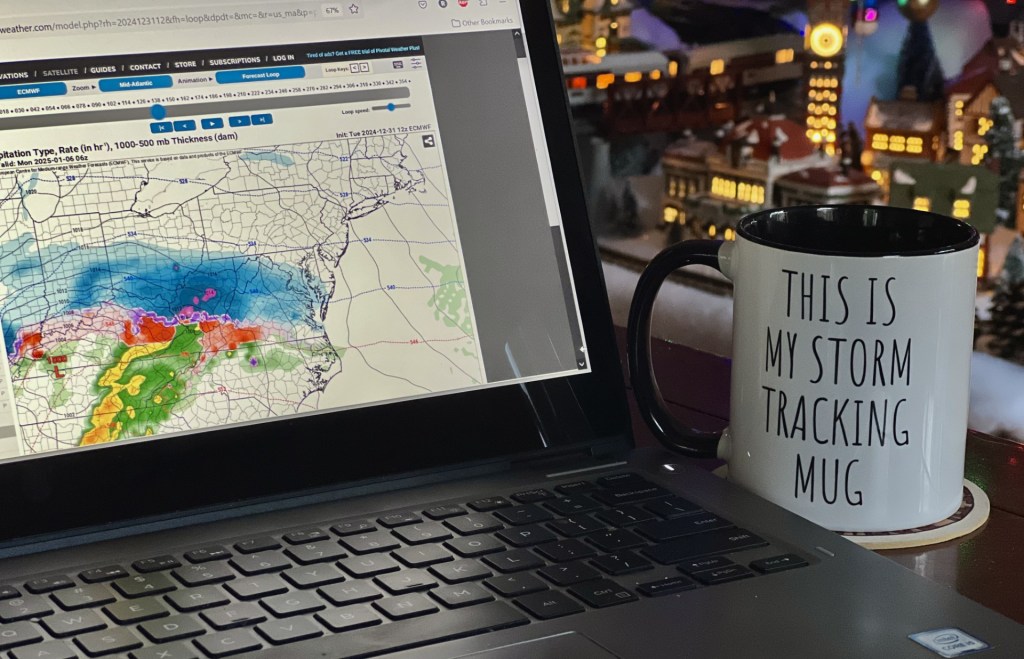
Anyway, back to our current storm. As I said, a couple of days ago I was becoming concerned that this north trend was happening to us, and as many of you know, it happens to us with frustrating regularity. But what was once our storm, was now becoming Philly’s, or even worse, New York or Boston’s. Every six hours, model run after model run kept ticking the storm north. Where we once were bulls-eyed by the storm, we quickly became underneath it as areas north of the Mason Dixon Line looked to get the goods. But, in a single run overnight Thursday, the Euro went from slipping north to suddenly way south. Richmond snow-weenies were high-fiving and northern MD’ers were kicking dust bunnies. The gfs also starting ticking south but not as drastically as the Euro. We were still going to get snow, but there is still a sickening feeling seeing (ridiculous and wrong) snow maps suggesting a foot of snow, and then six hours later seeing the same map with 3″ of snow. I know it’s unhealthy and I probably need medication, but once I get teased by a snow map, regardless of how much the 5% of me that is rational resists it, I get greedy.
Since then, the Euro stopped sagging south, stabilized, and in recent runs has ticked a bit north, but still too far south for central MD to get into the really greedy stuff. Don’t get me wrong. There’s a lot to like about the Euro. With the heaviest axis of snow to the south, so is the warm air, and as a result, we are in the low to mid 20’s all day Monday with a steady, fluffy snow that isn’t going anywhere. Per the latest run of the Euro, about 4″ of snow falls at the Mason Dixon Line and then increases to about 6″ in Baltimore and to 8″ just north of DC. So, a general 4 – 8″ of snow, and probably exceeding my biggest snowfall at home in years. I should be satisfied.
Meanwhile, the GFS is similar to the Euro but brings the goods a little further north. Like the Euro, snow starts around 1AM on Monday morning, but is heavier into the morning commute, maybe a dry-slot of light snizzle during the day, and then another round in the evening as the upper level low passes and transfers to the coast. Total snowfall on the GFS is about 6″ along the Mason Dixon Line, 8″ around Baltimore, and nearly a foot closer to DC.
Then there’s the NAM. The NAM is like your drunk uncle that passes out watching football during the holidays and wakes up occasionally to yell at the terrible call of a play on TV that’s actually a commercial for Levi’s. The thing is, that every once in a while he gets lucky, wakes up at the right time and makes a very good observation. Uncle NAM is showing a general 8 -10″ snowfall across all of central MD that frankly, isn’t too hard to believe. Just know that with snow, I’m irrational.
My personal opinion is that the dust hasn’t settled yet and we don’t know where the biggest axis of snow will be, and most importantly, how we get there. I do think it’s going to snow, and it’s going to be impactful. I just don’t know what path we end up taking. It would be great to wake up on Monday morning to moderate snow that continues all day and then stops just after sunset, but I don’t think it plays out like that. We are going to have to watch for all the regular caveats around here including the dry slot, a warm layer in the mid-levels that changes snow to sleet, and the dreaded “rob Peter to pay Paul” transfer of energy to the coast. I’ll save the meaning of that weather term for another day.
I’ll update later today.