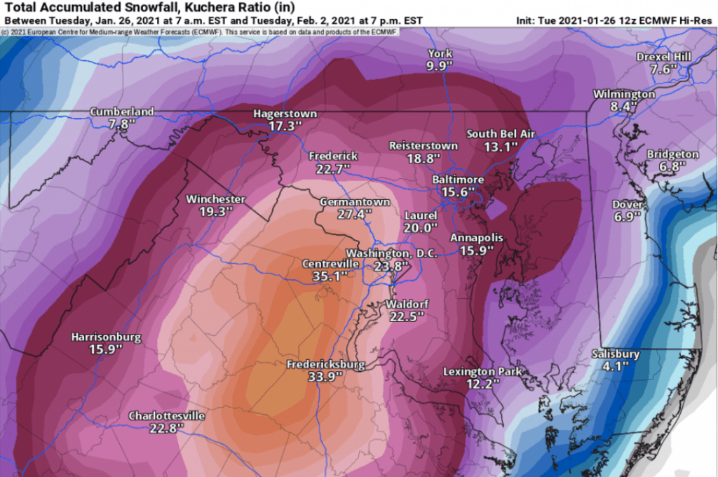
It’s going to be difficult to not get sucked in to believing snow is on the way as every major global model run this afternoon had an indication of a storm Sunday and/or Monday. Most of them are a moderate event from 3 to as much as 8 inches, but the European model, the same model with the best verification scores for years, dropped a snow bomb on the mid-Atlantic. I’m not going to bother going into any details for today’s run but there is a remarkable amount of agreement in the European ensembles that makes it hard to ignore.
For those that don’t know, when we look at the European weather model, we are looking at one of many simulations called the HRES (high resolution). Unfortunately, if there is any error in the initialization, and there always is, then the further out in time the model runs, the greater the error becomes. Obviously, the result is that a projected forecast is less and less reliable as time increases. One way to overcome this is to make a very slight adjustment to the initialization data and run a different simulation. Do that 50 times and blend them, and you get a mean or ensemble forecast.
The European HRES is considered the best model out there and is extremely accurate out to 72 hours. However, once you get past three or four days, especially in an active pattern such as what we are in now, it is better to look at the 50 member ensemble blend to see if maybe there are any outliers. If the HRES and the ensembles look anything alike, it gives confidence in the forecast. With that all said, the HRES model and the EPS (Euro ensembles) are in strong agreement that something is up. It’s just one run so I’m trying my best to not get too excited, but of all years, this is the year we need some snow.
Now, there is a ton of useful information on weather models, and admittedly, much of it is over my head, but one thing for sure is that snow maps are folly. They are never accurate and all they do is get the hopes up of snow lovers only to end up disappointing. With all that said, this snow map has to be shared. This is the Euro HIRES snow map for Sunday through Tuesday (courtesy of https://www.pivotalweather.com/model.php?m=ecmwf_full&p=sn10_acc&rh=2021012612&fh=loop&r=us_ma&dpdt=&mc=). And yes, that is a 39″ total in central VA.

I can’t share the ensemble maps that I have seen because of copyright concerns, but for a mean forecast of 50 members, it is a remarkable correlation. Yes, the mean is about half the snowfall of this graphic, but a 10-20″ snow on the ensembles is tough to ignore. Even better, the mean has the heaviest snow about 40 miles north, and most importantly, the placement of 45 of 50 low pressure systems for this event depicted on the mean are in a workable location for snow just off the coast.
Obviously, this far out it isn’t worth getting too invested in, but I’m feeling hopeful. I’ll update as things progress.
You just made my day Yore!!!!
Sent from my iPhone
LikeLike
I’m glad! By the way, we need to talk about you’re big first place in the Snow Contest!
LikeLike
Holy shit!!
On Tue, Jan 26, 2021 at 8:08 PM The Weather Mill wrote:
> theweathermill posted: ” It’s going to be difficult to not get sucked in > to believing snow is on the way as every major global model run this > afternoon had an indication of a storm Sunday and/or Monday. Most of them > are a moderate event from 3 to as much as 8 inches, but the E” >
LikeLike
Well said, Big Daddy.
LikeLike
You are soooo mean! Getting our hopes up like that!
Just kidding. I’m going to enjoy even the possibility of a big storm. It’s more fun than we have had in a long time.
LikeLike
I agree. By the way, the European model runs a shorter version during the evening and morning off hours, and this evening’s run still looks good. Keep your fingers crossed!
LikeLike
There can NOT be a big snow in DE. I made Alan sell his snow blower!!! He will kill me!
LikeLike
On behalf of all of us that love snow, we thank you. If we get a blizzard, we know you’re responsible.
And buy Alan a trowel.
LikeLike