I had written an update this morning, but it’s floating somewhere in space, so I’ll quickly recap. A storm will develop south of the area and likely impact the region Sunday and Sunday night. This is the type of system that could bring snow, sleet, rain, or a mix depending on the exact track of the low pressure center. Too far to the west and the counterclockwise circulation brings in warm air, so we want a track where the storm stays to our south and east.
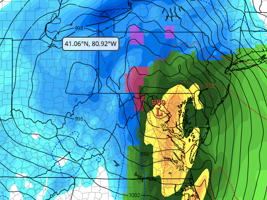
Right now, both operational models of the GFS and Euro show the storm coming too far west, and as a result, central MD starts with a period of moderate to heavy snow, then changes over to rain. However, both ensembles of the GFS and Euro show the low may still take a favorable track for snow (think of the ensembles as mean or average of many model runs where there are very minor changes to input). To illustrate my point, here is a graphic of this morning’s operational GFS run (graphics courtesy of Tropical Tidbits). Notice the position of the low center in the operational run. It’s much too far west for our liking resulting in warm air pulled in over central MD causing rain. The panels before this showed several hours of snow, but the predominant precipitation type is rain.
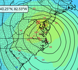
On the other hand, the ensembles, shown below, illustrate the uncertainty with this system. Notice the red numbers that show the position of the low center from all the output runs of the ensembles. If you took the average of all of those placements, it would be a point south and east of the operational shown above.
We are still five days out, so there will certainly be changes before Sunday. Hopefully for the good, but right now I think we might get slop. I’ll update periodically as things change.

Thanks for the graphics and the emphasis on the uncertainty of forecasting… would’nt it be better to flip a coin and go with it?
LikeLike
You’re welcome. I reserve my coin flips for bourbon or rye.
LikeLike