Thursday, February 19th, 7PM
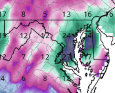
Just a quick update that a system will be impacting the area Sunday afternoon and into the overnight hours. There are ridiculous differences in the models for an event that is less than three days out, but the evening model runs gave some indication that they may be sorting themselves out. Hopefully by tomorrow there is some consensus. Right now there are two camps with the last few runs of the gfs showing a major to historical winter storm, while the euro is a minor daytime to possibly impactful nighttime event. For the past three runs, the gfs has been showing an all snow mauling in the one to two foot range (yes, I’m serious), and the euro is a mixed during the day Sunday becoming snow Sunday night in the 2 – 5″ range. I didn’t post about the gfs earlier because I thought it would eventually cave, but I have to admit that this evening’s euro was the first of the two models to flinch as it made a shift to a storm closer to the coast. It’s still nothing like the gfs, but I did not expect to see the evening gfs hold firm and the euro shift to an improvement for snow across the area. At this point, I still think they will meet somewhere closer to the euro, but I am reluctantly getting a little hopeful for one last winter hurrah. Anyway, I’ll update what the overnight runs say tomorrow morning and hopefully they all look like the ridiculous gfs shown below. But don’t get your hopes up. They won’t.

Sent from the all new AOL app for iOS
LikeLike